Wednesday, August 30, 2006

Back in the USA

We got up early this morning for a coffee and doughnut get-together with our fellow travelers. Many were heading in different directions but about 8 couples or so were all headed to Bangor ME. After all the warnings of what to expect at the border crossing and emptying all our refrigerators of beef, we sailed through the border with little trouble. the US agent merely walked through our motorhome and said he was looking for terrorists. We said we had none and he said" Welcome home". After some 47 days in Canada that sounded pretty darn good.

Tonight we are in Bangor. We filled up our fuel tank and that $2.99/gallon looked pretty good--are we nuts or what???? We spent the evening socializing. Tomorrow we will head to Bar Harbor so we can spend a week looking around Acadia National Park.

Monday, August 28, 2006

On the move

Well, we have been out of touch for a while and also have been moving. We spent a day touring the Louisburg Fortress in Nova Scotia. We will write more and post some pictures later. Yesterday we left Louisburg and drove to Truro, Nova Scotia.

Today we drove to St. John, New Brunswick. St. John is known as "Canada's most Irish city". We will explore the town tomorrow. In just 2 days, we will be back in the United States. Hard to believe we have been in Canada for 46 days. Will post more soon.

Saturday, August 26, 2006

Newfoundland to Nova Scotia

August 24, 2006

This is what we did on Thursday and Friday (24th and 25th)……

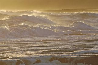
On Thursday, we packed up to move from Port Au Choix. The wind howled all night and most of us didn’t sleep very well! The ocean waves continued to pound the coast—a beautiful sight—but the wind just cut right through everything we wore. Many of us are also watching the waves because we are going to board the ferry back to Nova Scotia soon and we don’t want to be seasick.

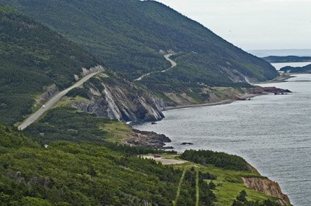
Our destination was Doyles, NF. It is a small town with a campground about 25 miles north of Port Aux Basques—the Newfoundland- Nova Scotia ferry terminal. Although the drive along the coast was lovely, the wind was relentless and when you combine that with the bumpy Newfoundland roads—it was long 300 miles. We kicked back when we arrived, threw our last steaks on the grill (have to use up our beef before we cross the border) and went to bed early since we have to leave our campground at 5:00 am for the ferry.

Bright and early the next morning—wait it was still dark!—we got up and left for our 25 mile drive to the ferry terminal. The procedures were similar to our previous ferry crossing—hurry up and get there to be lined up and wait for loading. All went smoothly though thanks to the great planning (as usual) by our group leaders.

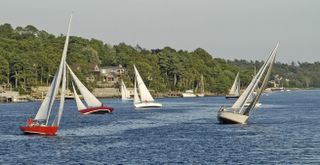
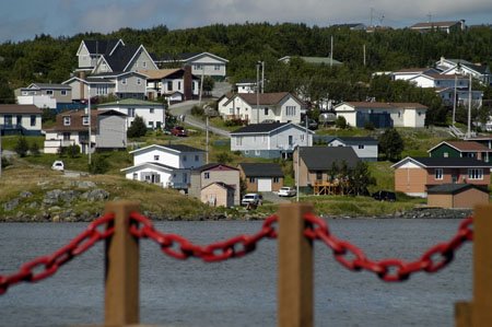
The first hour or so of the 6 hour trip were a bit rocky but eventually the ocean smoothed out and with a bit of a tailwind (or is it favorable seas?) we actually arrived in North Sydney, Nova Scotia ahead of schedule. Our destination for the next 2 days is Louisburg, Nova Scotia, about 40 miles south of the ferry terminal. Bright sun, blue skies and a gorgeous waterfront campground greeted us in Louisburg. Louisburg is on Cape Breton Island—the northern section of Nova Scotia.

All of us were pretty tired (up at 4 am!) but we had tickets for a performance at the Louisburg Playhouse after dinner. We walked up the hill behind the campground to the playhouse. None of us was too sure what we were going to see except we had been told it would be a good musical performance.

The Louisburg playhouse has an interesting history. In 1993, Disney announced that Squanto: A Warrior’s Tale was to be filmed at Louisburg. Filming required the construction of a 17th century timber-style theater that was modeled after Shakespeare’s original Globe Theater in London. The theater was featured in several scenes in the movie. After filming at the Fortress of Louisburg (we visit there tomorrow) was complete, the theater was donated to the town. It was dismantled and moved from the Fortress to its current site along the waterfront. It originally opened as an open air theater and later the town raised money to enclose it and add heating and lighting.

Our show was put on by a group called Lyrics and Laughter. The show is described as: “A spirited performance of ape Breton music and comedy in the historic atmosphere of the playhouse”. Well, in short it was fantastic!! The six musicians sang, danced and played traditional Scottish folk songs, Irish folk songs as well as original songs. They played piano, guitar, fiddle, bodhran( an Irish drum), banjo, flute, tin whistle and accordion. It was a high-energy performance that woke everyone up. What a great day to finish the day.


As the sunset, the surf continued to get rougher. Port Au Choix, Newfoundland


The surf was pretty rough-This is the view from the motorhome. Port Au Choix, Newfoundland


This rock face looks like a face to us--Do you see it? Taken in St Anthony, Newfoundland

Port Au Choix Newfoundland

This is what we did on Wednesday….

Today we begin to head south. Having reached our furthest point north, we are now on our way back to the US. Our destination for today is Port Au Choix-about 125 miles south.

Our campground is right on the ocean and we have a beautiful view. I am sitting at the computer writing this as I look out over the ocean. Although it is sunny and clear, it is very windy and the waves and surf are quite rough. We took a walk along the beach to enjoy the beauty.

The local Lions Club hosted a dinner for us. We had a fun time when some of the locals sang and danced for us. The Newfoundlanders have their own traditional music and we have really enjoyed listening to that. We have even learned a few words to sing along. Learning a few words is no small feat as the Newfies have their own particular language. It is a mixture of English with an Irish/Canadian accent and many of their own words. It’s fun to listen to them.

Tomorrow we head further south to Doyles,Newfoundland.

Monday, August 21, 2006

Labrador

This is what we did on August 21st….

This morning we got up early to make the 90 minute drive to St. Barbe, Newfoundland. This town is the terminal for the ferry to Labrador. Once again we have bright blue sky and sunshine and locals tell us we are very fortunate!

Tickets in hand, we walked onto the ship for the 90 minute, 18 mile crossing. Nice weather means smooth seas too and for that we are thankful. This is the ferry at the dock with the bow opened so cars and passengers can disembark.

The first place we visited was a burial mound. This is what it looks like—how people figured this was a burial mound is beyond us. However, this is the oldest documented burial site in North America. It dates back 7500 years!

Next we visited Point Amour Lighthouse. This is the tallest lighthouse in Atlantic Canada. It was built in the late 1850’s. Jim climbed the 128 steps up to the top for a panoramic view of the Labrador Straits. It is such a clear day he could see houses on the Newfoundland coast some 9 miles away.

Next, we visited the town of Red Bay. In the second half of the 16th century, whale oil was a rare and highly prized commodity. It burned brighter than the more common vegetable oils, and was used in the manufacture of soap, treatment of fabrics and in pharmaceutical products. By the mid-16th century, European fishermen were pursuing these valuable commodities by exploiting the rich marine resources of the Strait of Belle Isle( the area we are in). Basque merchants and ship owners in France and Spain mounted regular seasonal expeditions to the south coast of Labrador and the north shore of Quebec, to hunt whales for their oil and other products. They favoured the port they called Butus, now called Red Bay.

Underwater archaeological excavation began in 1978 and over the course of the next six years, The Red Bay Project developed into one of the most comprehensive marine archaeological projects ever undertaken in Canada. The discovery of three Basque whaling galleons and four small whaling craft makes up one of the most precious underwater archaeological sites in the Americas. One of the small craft, an eight-metrer whaling chalupa was found pinned beneath the collapsed starboard side of a 200-tonelada whaling vessel. The chalupa was excavated and meticulously recorded prior to its complete disassembly, recovery, conservation and re-assembly. Its 400 plus-year old remains are highly valued.

We did not bring our motorhome over to Labrador since we are only staying overnight. On our way to our hotel we passed through the Pinware River Valley. Steep hills and large trees line the river. Otherwise, most of the areas along this coast are covered by small stunted spruce and large glacial deposits of rock. The picture on the left is of part of the town of Red Bay.

We had an enjoyable day before we headed into the hotel for dinner. Some of our group had caribou roast but we stuck with the cod and it was delicious.

Tomorrow we head back to Newfoundland.

Viking History

This is what we did on August 20th…

This morning we went to the L’Anse aux Meadows National Historic Site. This site is the first known North American Viking settlement. The Viking settlement known in Norse literature as Vinland dates back to 1000 years ago. It was founded by a group lead by Leif Eriksson.

In the 1960’s, Norwegian archaeologists, Dr. and Mrs Ingstad had been searching for the legendary site of Vinland. They visited L’Anse aux Meadows and spoke with a local fisherman named George Decker. He told them of unusual grassy mounds in the area. Twelve years of research followed and the Ingstads proved that the grassy mounds were remnants of eight 11th century Norse buildings. Remnants of early iron production were also uncovered. at L’anse aux Meadows. It is thought to be the first place in North America where ore was smelted to produce iron.

The national historic site encompasses those mounds and also had recreated buildings showing how the Vikings lived while at the site. Costumed workers re-enact many of the Viking activities and provided a lot if information. (5293).

We also visited the Norsestad Village which is a re-enactment of the Viking Village. Various crafts and games were demonstrated.

Later in the day we drove into St Anthony and toured around the town. One of the places we visited was the Grenfell Experience. St Anthony is the headquarters of the Grenfell society founded in the late 1800’s by Sir Thomas Grenfell. Dr Grenfell is credited with bringing medical care to Northern Newfoundland and Southern Labrador. He spent most of his life going from village to village caring for people and was instrumental in setting a comprehensive hospital system. He was an interesting man.

In the evening we went out to the St Anthony lighthouse. (5357). It is a popular spot to look for whales although we did not see any today. We attended a Viking feast which featured traditional Newfoundland and Viking dishes such as Jigs Dinner(salt beef with potatoes, turnips and cabbage-pretty good), cod tongue, caplin(small salted fish-yuck!), salmon and cod. The entertainment by the Viking costumed staff was really fun. They held a court and various audience members had fun bringing charges against their fellowe travelers. It was great fun and we all laughed a lot.

St Anthony

This is what we did on August 19th…

It’s another rainy day—but also another travel so it’s OK to have gloomy weather for driving. We left Rocky Harbor for a 210 mile drive along the St Lawrence gulf coast to St. Anthony. We left bright and early because we had been warned that the road was very rough in spots and had lots of frost heaves.

Well, the road was pretty variable. There were some sections of brand new pavement. When the road was good, it was very good, however, when it was bad, it was very, very bad. That made it interesting when we parked—you never know what will come flying out a cupboard!

The coast line was rocky, windswept and very desolate. We went though a few very small towns. They are so isolated! Most of us have decided that the residents are hardy souls who are quite self sufficient. You have heard the saying-- A great place to visit but I wouldn’t want to live there—this is what they are talking about!!

One interesting thing we saw along the roads is vegetable gardens. The gardens are literally beside the main roads. It seems that when the highways were put in that these wide areas that were cleared and filled have some of the best garden soil in the area. Most of Newfoundland is very rocky—in facts Newfoundlanders refer to their island as “the Rock”. Being resourceful they use this nice area along the highway to plant a summer vegetable garden. Potatoes, carrots and turnips are grown for winter food. Each person fences off their garden. Often flags are hung to deter birds and other wildlife from raiding the garden. The gardens are planted on an honor system—no one messes with another person’s garden.

One also sees enormous stacks of firewood along the road. Wood is gathered in the spring (by snow machine and sled) and stacked for drying over the winter. Again, the honor system is used—no one messes with someone else’s’ wood supply. Locals tell us that 8 cords can be cut every year by permit. Many of the residents in this area go 10 miles or more from the coast to get to the forests.

We arrived in St Anthony and found clearing weather. Later that evening we went out looking for moose. There are 350,000 moose in Labrador and Newfoundland; it should not be so hard to see some! We did see 3 or 4 finally.


5193 moose

Friday, August 18, 2006

Exploring Bonne Bay


Today we took a water taxi from Norris Point to Woody Point on Bonne Bay. The two fishing villages are only about 2 miles from each across the water but are 65 road miles apart. The bay’s water was glass smooth on both trips and the taxi crew was full of Newfie humor.

After seeing several boats working the harbor, we asked what they were fishing for and the answer was cod!! This bay was deeply scoured by the receding glaciers and they can jig for cod right inside because of the depth. These fishermen can also set snow crab traps at the cold depths and lobster traps closer in to shore where it’s shallower. The best of all worlds!!

The unique geology of the whole area is something to see. In 1987, Gros Morne National Park was declared a World Heritage Site for its geological importance. It has huge tabletop mountains, river accessible fjords and a large scenic coastline on the Gulf of St. Lawrence.

Going fishing


After arriving at the Gros Morne campground on the 16th, a couple of us were able to set up an early morning fishing trip with a local cod fisherman. The residents of Newfoundland are now allowed to take 5 cod per day (up to 15 cod in the boat) during the month of August. At 0630, three of us went out with the local man and his wife into the North Atlantic about a mile from Rocky Harbor so we could jig for cod.
We could only use heavy hand lines dropped to 20-22 fathoms to jig. The current was running hard and we drifted off the fish very quickly so boat captain was constantly raising the dragging anchor and repositioning us over the deep water.
Between us we only caught 8 of the 15 fish allowed before heading back to the harbor. That jigging is hard work and if you get a cod on, it’s like catching Alaskan halibut! You’re pulling up the heavy weighted jig and a non-swimming fish. Oh, but fresh cod is so very good to eat!! This is a photo of the crew skinning the cod.
We have also purchased a couple pounds of mussels at $1.29/pound, so Karen is in Heaven!! Somebody in the caravan suggested we have a fish fry for dinner so the ladies went down to the local fish market and purchased enough fish to feed us all. The men cooked it all up and we had a great social dinner. We had catfish, cod and salmon along with all the various pot luck items everyone provided. Then unknown to us, the wagon masters made arrangements for local entertainment to bring the day to a close.

Wednesday, August 16, 2006

Rocky Harbor, Newfoundland

This morning we pulled out of Botwood to travel to the west coast of Newfoundland. Our destination was the small town of Rocky Harbor and Gros Morne National Park. Our drive took us through some rugged and hilly country. Although it was intermittently rainy and foggy, the drive was beautiful. We passed some enormous lakes and large rivers. Newfoundland has more fresh water (lakes and rivers) than any of the other provinces.

While here in Rocky Harbor we will be exploring Gros Morne National Park. This National park is known for its landscapes of mountains, fjords and scenic coastlines.
We look forward to seeing the park. Apparently the park is also home to lots of moose and caribou. We have yet to see any Newfoundland moose and we are beginning to think they are a myth! We shall see.

Our campground has Wi-Fi so we will be in touch for the next few days.

Tonight’s sunset was pretty.

Botwood Newfoundland

This is what we did on August 15….

Today we made the short drive to Botwood, Newfoundland from Gander . Botwood is situated on Exploit Bay. Botwood is a port for ships to carry paper from the large paper mill some 60 miles from here. It used to be a port for mineral shipments. More importantly in its history is the role Botwood played in WWII as a sea plane base for anti-submarine patrols in the North Atlantic. This is what the sea planes looked like. It was also the first commercial flying boat seaport and refueling stop for Pan-Am Clippers in 1939. The runway for the sea planes is where we parked our motor home overnight.

While here in Botwood, we took a tour on the “Bumpy Blue Bus” to Fortune Harbor. Once there (50 kms. of scenic but very bumpy roads) we boarded a barge type boat. We toured around the harbor and learned some of the history of this tiny village. During times of plentiful fishing, Fortune Harbor was home to 700+ people. They were quite isolated with no roads connecting them to the rest of Newfoundland. The roads came in the 50’s and 60’s. The cod fishery was shut down in 1992 and the current population is only 89. Fortune Harbor is now home to a mussel farming operation. This photo is of another village on the way to Fortune Harbor but it looks very similar.

We went out to the mussel farm and learned how they are cultivated. In the cold waters of Newfoundland, it take 2 ½ to 3 years for mussels to grow to a harvestable size. These blue barrels are floating on the water some 20-30 feet above horizontal lines that contain strings of growing mussels. The photo on the left shows a line pulled up by the boat. The ropes of mussels cling on to the line and to each other as they grow.
After explaining the long process of getting the mussels started on the ropes, we got to eat a few of the tasty critters---delicious!

After our boat tour, we went in to the owner’s home and were treated to entertainment by a local singer and learned more about Newfie customs and music. We got to sample Screech—Newfoundland rum.

We boarded the bus for the bumpy ride back. We were treated to a potluck dinner hosted by the Catholic Church Women’s group. There were lots of homemade dishes including local favorites such as moose stew, fish cakes and salmon. They also entertained us with local songs. It was a fun evening. This small town is so friendly. The little museum and gift ship at the seaplane base stayed open until we got done with dinner just for us.

Speaking of the museum, it was a pretty interesting place. It showed lots of photos and displays about Botwood and its role in WWII. Roosevelt and Churchill met here a number of times! Such a remote place that most Americans never even heard of! It was a fun and informative visit.

Last Day in Gander

this is what we did on August 14th....

We awoke to another sunny day! Boy, are we lucky. It’s supposed to rain tomorrow of course.

Our campground hosts cooked us a “Newfie” breakfast. It consisted of eggs, bacon, Newfie steak, brewis, and tauntons. Of course eggs and bacon are well known. Newfie steak is fried bologna.. Brewis is hard tack soaked overnight in water then cut up and fried with onions—interesting—they eat it with molasses. Tauntons are griddle fried pieces of bread dough—a cross between a pancake and French toast. It was actually pretty good. The cook says for lunch or dinner they would eat fisherman’s brewis –the same water soaked hard tack combined with salt cod and fried—hmmm.

We relaxed through the rest of the day. In the evening we got together and had a Mexican fiesta. Walking tacos, salsa, all the trimmings and margaritas--yummy. Guess that taste of Mexican food made us hungry for more. Actually, as we start to near the end of our time in Canada, we have to find ways to get rid of extra meat we are carrying because we can not bring it back into the US. The same goes for some of the tequila—too much to bring back without duty. Any excuse for a party!!

Tomorrow our destination is Botwood.

Sunday, August 13, 2006

Touring Gander

Today we woke up to sunny skies—Yippee, no rain!! We were quite happy to see the nice weather. Locals tell us this is the 2nd sunny day they have had since the beginning of July, so we feel quite fortunate. We toured around town a bit.

Our first stop was the Silent Witness Memorial. This park is dedicated to those individuals who lost their lives in the 1985 Arrow Air Crash at that site. The 256 victims were members of the 101st Airborne Division of the US Army. The Memorial is a statue of an American soldier holding the hands of two civilian children. The children, a boy and a girl, each hold an olive branch, indicative of the peacekeeping mission of the 101st Airborne on the Sinai Peninsula.


Also at the site is the Cross of Sacrifice. Paid for by donations from site visitors, it is inscribed with the Airborne motto “Rendezvous with Destiny”. The cross is crafted from the remains of the emergency door of the ill-fated DC8. 256 native trees were planted around the cross-a tribute to each of the crash victims.


Our next stop was the North Atlantic Aviation Museum. Since aviation plays such a huge role in the past of Gander, the museum is very important to the town. They have a number of aircraft on display as well as details from their aviation history. One of the large exhibits depicts Gander’s role and response after 9/11. All of the letters of gratitude sent to the town as well as many photos depicting their response are on display.


For dinner our campground hosts cooked us a steak dinner. It was delicious. After dinner the host told us a bit about the town and how people live in this part of Newfoundland. He gave us some more details about 9/11 and how Gander dealt with it. He was actually an air traffic controller on duty at the time so his perspective was quite interesting. We finished the evening with a visit from the town mascot-Commander Gander- who gave us all town pins. These Newfoundlanders are very friendly.


We loved the streets of St John's and even though we left yesterday we thought we would show these to everyone.


The rows of colorful houses line the hills of St John's.

Gander, Newfoundland

This is what we did on August 12th…

This morning we packed to leave the charming city of St. John’s. Our destination: Gander, Newfoundland, about 210 miles away. From extreme southeast Newfoundland we traveled toward the north central part of this huge island.

Although there was a bit of fog, it was a beautiful drive. Lakes (called ponds here) of varying sizes are all over the landscape. They all seem to be a deep blue color and with the wind looked pretty rough. We looked for moose at every turn but they were all hiding in the bushes!

We drove through Terra Nova National Park. It is a wilderness area with lovely hills of spruce and vistas looking to the sea. While beautiful, the fog and drizzle prevented us from getting some nice photos.

We arrived in Gander under overcast skies that threatened rain at any moment. We got parked and set up before it let loose with a fairly steady rain. This area and the weather at the moment reminded us of August in Fairbanks, Alaska!

We learned a little bit about the town we are in. Gander is a very young town—what a contrast to St John’s that we just left! During WWII, this area was a beehive of activity surrounding the strategic post of the Royal Air Force Ferry Command. The airport was shrouded in secrecy as fleets of American bombers and fighter craft were transported overseas. After the war, the airport reverted to civilian control and in the early 1950’s, the construction on the town site of Gander began. Today Gander is still an important place in aviation circles as the first landfall for trans-Atlantic flights. On 9/11, 38 commercial airliners were diverted here when US airports closed.

Tomorrow, we hope for better weather. We plan to tour the area and its sites.

Friday, August 11, 2006

Marine Lab Tour

This morning we were scheduled for 9:30 am tour of the NRC Institute of Ocean Technology. The center was only a short 1 mile drive away. After wrangling one of only a handful of parking spaces, we were ushered in to begin our tour.
The Institute for Ocean Technology (IOT) was established in 1985 as Canada’s national center for ocean technology research and development. IOT’s capabilities are unique to the nation—no other organization in Canada offers the combination of knowledge, experience and facilities available here.
One of IOT’s main research program focuses on predicting performance in marine environments. They can study ice forces on structures and vessels, propulsion systems, safety at sea, aquaculture engineering, underwater vehicles, deepwater technology and hydrodynamic forces due to wave impact. Off-shore oil rigs, ice breakers, submarines and racing yachts are few of the vessels studied.
We were shown the model prep workshop where precise scale models of various vessels are engineered to exact specifications. Not only are the models accurately reproduced but they are outfitted with arrays of sensors that can be read to measure effects of the testing. Models up to 12 meters in length can be manufactured. What a great job for adult model-builders!
We saw the Offshore Engineering Basin. Measuring 72 x 32 meters and 3 meters deep, it is one of the worlds’s most advanced indoor facilities. The basin is equipped with current generators, wave makers and fans to simulate wind.
Next we visited the Institute’s Ice Tank. At 12x 16 meters, it is the longest ice tank in the world. The IOT is capable of producing sheets of ice up to 6 inches in thickness. Testing of ice forces on various structures (such as the towers on the Confederation Bridge) is conducted here. Air temperatures in the tank area can range from -30 to +15C. Today the room was a brisk -11C. Good thing we remembered our jackets!
Last we visited the 200 meter towing tank. Much secret research is conducted here for various teams participating in the America’s Cup Yacht races. The 2003 winner from Switzerland used the facility to help perfect their keel engineering. Today tests were being conducted on a small model of a racing yacht. Of course, none of us knew exactly what they were studying. Apparently the area we visited was just recently opened up for tours.
We finished up by watching a short video that showed the IOT research areas in action. It’s a pretty interesting place. Too bad they don’t allow photos of their facilities.

Thursday, August 10, 2006


We went out on a boat to look at Atlantic Puffins. We were supposed to see whales but the seas were too rough! They are only 8 inches tall! The little guy in the front is taking off.


These 2 puffins liked to pose!

St John's Newfoundland

This is what did on August 9th…..

First of all… last night a group of us went to the Mexican Restaurant in downtown St. John’s. Imagine going this far North to eat Mexican food! It was actually pretty tasty.

This morning we awoke to cool, overcast weather to take a tour of St. John’s, Newfoundland. We piled on a bus and listened to our guide to learn about this largest city in Newfoundland.

Facts we learned: St John’s is the oldest city in North America continuously inhabited by Europeans and their descendants.
It was settled in the 1519.
The Mayflower stopped here for provisions in 1620.
St. John’s and the area fisheries were fought over by the French and the British.
Newfoundland was an independent nation until 1947 when it became a province of Canada.
St John’s is at the same latitude as Seattle, Washington and Paris, France.
Newfoundland and Labrador have a population of approximately 500,000—of that number nearly 300,000 live in St John’s or its surrounding area.

Our first stop was Cape Spear. This is the eastern most land point in North America.
It was really windy and somewhat chilly but Jim made the hike out to the point.

Next we went to Signal Hill National Historic Site. Signal Hill sits on a hill (surprise) overlooking St. John’s Harbor entrance and the surrounding ocean. It served as a center for the town’s defenses. Signaling cannon was placed on the hill in the late 16th century during the Napoleonic Wars. A system of flags flown on the hill warned ships of sea and weather hazards.
The Cabot tower was built on the hill in 1897 to commemorate the 400th anniversary of John Cabot’s discovery of Newfoundland and Queen Victoria’s Diamond Jubilee.

It was also on this site on 1901 that Italian inventor Guglielmo Marconi received the world’s first radio transmission, sent in Morse code, from Cornwall, England.

We drove through the narrow downtown streets of St John’s. Housing is row after row of colorfully painted row houses. Some of the old homes are beautifully restored.

We visited the tiny fishing village of Quidi Vidi. In addition to its charming little harbor, it is home to the oldest unaltered building in the area. It was built in 1750.
It is also home to a local brewery making some tasty beer.

We finished our day by doing a little grocery shopping. Tomorrow we are going on a whale watch boat tour. The forecast is typical “Newfie” (that’s how Newfoundlanders refer to themselves) weather: RDF (rain,drizzle,fog)


A view of our motorhomes parked in Placentia ,NF taken from an old French fort overlooking the harbor. We are 2nd from the right.


Karen waiting to get on the ferry to Newfoundland -note the long lone of RV's behind her. The ferry can carry 70 of them.

Tuesday, August 08, 2006

North to Newfoundland

This is an update for August 7th and 8th….

This day began very early—we left our campground at 12:05 am!! Our destination was the Newfoundland Ferry loading dock. They wanted us to arrive that early for a loading time of about 5 am. So after our short 5 mile drive, we took a nap waiting our turn to load.

About 5:15 am we drove on to the ferry. Our ship is much bigger than the Alaskan Ferry ships we have seen before. It holds a large amount of truck traffic as well as lots of vehicles and motorhomes. They have 2 vehicle decks and 5 floors above. Our trip is about 275 miles but takes 14 hours! Smooth seas. The food on board was good and there was entertainment (by Newfoundlanders) in the lounge that we enjoyed tremendously. The time went pretty fast.

After we docked, we drove through the tow of Argentia. Argentia is home to the place where Franklin Roosevelt and Winston Churchill signed the Atlantic Charter. This was the beginning of the United Nations.

We stayed overnight in Placentia, a small fishing village near Argentia. This morning, we looked around the town of Placentia and found a Canadian Historical Site called Castle Hill.

Castle Hill is the site of a large fort built by the French in the late 1500’s. It was the site of many battles between the English and French. The plentiful fishing grounds were prized by both countries. Eventually the English won out and later the major defense of the area was moved to St. John.

Later we drove on in to St. John, the capital of Newfoundland. We are getting settled in our campground and will be here for a few days to look around. We found a free internet site so you get to read this update!

Saturday, August 05, 2006

North Sydney, Nova Scotia

Saturday August 5th...

This morning we changed locations again. This time we are in North Sydney, Nova Scotia. This town is the port for the NewFoundland Ferry. On Monday morning we will board the ferry for the 14 hour ride to Argentia, NewFoundland.

Our campground has wireless internet so we are able to update our blog. We are finally too far North for our own satellite dish to work. So...for the next few weeks, check in and see what we are up to. We will update whenever possible.

Sunday August 6th...

Our second day here. We kicked back and did chores around home. This morning we got to meet Ron and Juanita, the owners of Adventure Caravans, as they stopped by our campground. That was neat. We washed some of the last several weeks dirt off the motorhome. I'm sure it will rain now!
Tonight we are going out to dinner (more lobster!) to say good-bye to a few of our fellow travelers that are leaving and welcome some new ones for the 2nd half of the trip.
After that, we leave for the ferry at midnight.


Grain elevator in Halifax Harbor. It's quite a long ride!


Does anyone see Star Wars here?


Which way to the turn buoy?

Cabot Trail

This is what we did on August 4th…..

Early this morning we boarded a bus to tour the north end of Cape Breton Island on a road known as the Cabot Trail. This trail, named for John Cabot who first landed here in 1497, is about 185 miles long and has some of the most spectacular coastline scenery in Canada.

This area was initially settled by the Scotch, Irish and French Acadians. Initially, the main industry in the area was coal mining and fishing. Years ago, about 30 million pounds of cod were shipped to France every year. There were 12 coal mines in the area with some them having tunnels 4-5 miles long that went out under the Atlantic Ocean. Now the cod fishery is extremely depleted and fishermen now harvest lobster and crab. The coal mines have shut down and tourism is a major industry.

We passed through a number of coves surrounded by small fishing villages. It seems that no matter how many of these we see that we still enjoy seeing these picturesque settings. Lobster season has ended for the year in this area so most of the harbors are stacked with lobster pots in readiness for the next season.

The very northern end of the island is home to Cape Breton National Park. This largely wilderness area is loaded with gorgeous scenery and a lot of moose. Karen thought the Canadian Moose was a myth because we hadn’t seen any on the trip yet! We also saw eagles and whales from “lookoffs”. Lookoff is the Canadian equivalent of our “overlooks”. There are several steep mountains that go right down to the sea. Our roads were up to 9% grades several times!

We stopped at a French Catholic Church named for St. Peter in the town of Cheticamp. It has the most beautiful church interior we’ve seen. The church serves 900 French speaking families in the area.


We then stopped at a garden party at Joe’s Place. Many years ago Joe retired and went about making a garden at his house along the highway. To deter the birds from eating all his crops he made elaborate scarecrows. So many people stopped to photograph the scarecrows; he gave up on the dismal garden and added more scarecrows of different people, real and imaginary.

Joe has passed on but his son has continued adding/changing scarecrows through the years. He has also added an ice cream parlor to the property. These people up here do LOVE ice cream. Of course, so do we!!

Bluenose II and harbor tour


This is what we did on Aug 02....

Jim took a trip on the all wood sailing vessel BluenoseII that was built from the original Bluenose plans. The original Bluenose was known as the Queen of the North Atlantic because she won every race for the International Fisherman’s Trophy for 18 years. Both ships were built in Lunenburg, Nova Scotia and the Bluenose II is berthed there when not out sailing on tours/training. The co-ed crew of 16 lives aboard for the 6 month sailing season and receives seamanship instruction. On the sailing today, the Captain rotated 4 different crew members through the steering position. The 4150 square feet of main sail fabric is the largest working mainsail in the world. She has a total of 11139 square feet of sail fabric that has moved the 285 ton ship at 16 knots.
The photos of the ship don’t do her justice as it was impossible to catch all of the sails at one time. The morning was very foggy when we arrived but it rapidly cleared and we motored out of the harbor right on time. After clearing the harbor channel, the crew raised all the large sails and we sailed for over an hour in various directions. The sailing experience was well worth the $34.00 fee! The ship is operated by the Lunenburg Marine Museum Society. If you want to see more of the ship and the museum visit www.museum.gov.ns.ca/fma .
In the evening, we went on a dinner cruise through Halifax harbor while learning the local history of many of the area’s parks and structures. Halifax is reputed to be the 2nd largest natural deep water harbor in the world. No, we didn’t find out what harbor is the largest. After such a hot day, the evening breezes on the water was a welcome relief.

Today we’ll put in more photos, the captions will be aside them if this works right!

Look at the wheel spokes..one of them is totally different than the rest. It is the King Spoke..it gives the position of the rudder angle in relation to the keel.


This photo shows just how difficult it is to change direction. The Captain, facing forward, said "starboard easy" and she had to change the wheel with all her strength!! Well, it was easy for somebody!!


In this photo, he provided her with a quick bit of manuvering instruction after she didn't accomplish the task quite as quickly as he expected. He and his first mate were very ready to assist and instruct each of the helmsmen as we sailed!

It took all hands to fold the mainsail onto itself as we finished the sailing and motored back to port.

.