Sunday, July 30, 2006

Halifax

This morning we got up and made a short drive to our next campground, outside of Halifax, Nova Scotia. The drive was lovely with lots of scenic vistas overlooking the ocean.
We have several activities planned while we are here so watch for future postings on that.

Lunneberg Nova Scotia


This morning we attended the Annapolis Royal farmer’s market. As with many farmer’s market, there was a beautiful assortment of fresh vegetables. In addition there were fresh baked goods and some unique arts and crafts . Fresh vegetables always taste so yummy and we did buy a few.

Later, we drove to Lunneberg, Nova Scotia. This quaint fishing village is on the Atlantic Ocean (as opposed to The Bay of Fundy where we were before). Lunneberg was formally established in 1753 as the first British Colonial settlement in Nova Scotia outside Halifax. Settlers here were from Germany, France and Switzerland. Farming, fishing and ship building were the basis of the economy during the last 2 centuries. Although ships are no longer built here, fishing and farming remain important to Lunnenberg’s economy today.

We went to the Atlantic Fisheries Museum. This large museum tells of the history of the area and how the fishing industry worked in years past. The cod fishery, located off the Grand Banks, provided most of the work. Prior to the huge modern fishing trawlers, fisherman worked in small dories to catch fish. A number of dories were transported on large ships out to the fishing grounds. Two men fished in the small dory until they were full and then they went back to the big ship. This is a photo of a dory on the larger ship. What miserably hard work!

The museum also had an aquarium which displayed many of the species commonly caught in the area. They also had a tank with lots of large-no huge—lobsters. They also had this guy in a case. He used to be a resident of the aquarium before he died. He was caught off Georges Bank and weighed 25 pounds. The record lobster caught off Nova Scotia was 44 pounds in weight. Those would be some enormous critters!


The other thing the museum is famous for is that it is home port to the BlueNose II. The BlueNose II is an exact replica of the BlueNose. This schooner, pictured on the Canadian dime, was known as the Queen of the North Atlantic in the 1920’s. Jim is scheduled to sail on the BlueNoseII next week so look then for photos.

The last “fun” thing we did today is to fill up the jeep with gas. Why was this “fun”? Well, it was the first fuel we had bought in Canada for the Jeep (we have taken tours and ridden with other people and driven short distances). That tank of fuel was $75.00!! Ouch!!

Friday, July 28, 2006

Annapolis Royal

Today we toured some of the historic areas around Annnapolis Royal. Over time, it became the first capital of Nova Scotia. Later the capital was moved to Halifax where it remains today.

The compound or habitation as the Canadians call it, is named Port Royal. This place was the site of the first French settlement in 1605 and was one of the earliest European settlements on this continent. Mi’kmaq (native) people lived along these shores for centuries and it was here that the French and Mi’kmaq formed an enduring friendship and alliance. The Habitation survived until 1613 when it was destroyed in an attack by Capt. Agall of Virginia. This is a view from one of the gun ports. These guns were never fired in anger, only as a signal.

We looked at the different rooms of the workers who lived in the Habitation. Only men were included in the initial settlement which had several purposes including fur trade (beaver) and exploration. Guides went over the history of the group and demonstrated various aspects of their lives. This was one of the guides dressed in period costume. Note the wooden shoes-he said they are comfortable!

Next we toured Fort Anne in Annapolis Royal. Situated strategically on 2 rivers and near the Bay of Fundy , the French and British in turn had their colonial capitals here. It was one of the most hotly contested territories in North America, enduring alternating sieges and attacks from the French and the British seeking control of the continent.

The earthworks of the fort are in the star shape, similar to other forts we have toured such as Ft McHenry in Baltimore. Fort Anne is the oldest national historic site in Canada, designated in 1917. This gunpowder magazine building is the oldest original building in Canada.

One of the really neat things at Fort Anne is a needlework tapestry on display. The tapestry depicts 4 centuries of the area’s history. It was stitched by over 100 volunteers and even includes a few threads placed by Queen Elizabeth. The guide told us there are more than 3 million stitches in it. It was really impressive work. These photos are of 2 of the panels. It is hard to see all the exquisite detail in this massive work.

We had a nice lunch and spent some time walking through a small botanical garden overlooking the Annapolis River. The Victorian gardens were especially pretty but our time there was cut short voluntarily by the hordes of mosquitos that were also admiring the flowers!

Tomorrow, its on to Lunnenburg, a small fishing community.

Grand Pre' National Park

This is what we did on July 27…

Today, we traveled from the village of Noel to Annapolis Royal, Nova Scotia. On the way there we stopped at Grand Pre’ National Park.

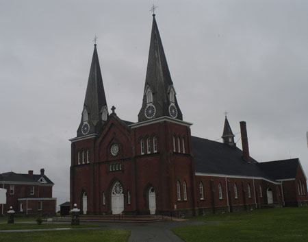
At Grand-Pré, we get to know the Acadians, Nova Scotia’s early French settlers. Theirs is a story of pioneer life, tragedy, and triumphant survival. This commemorative site was the heart of the 17th- and 18th-century Acadian village that became the scenic setting for Longfellow’s enduring narrative poem Evangeline, and includes a church and an unmarked Acadian cemetery. This is a photo of the re-built church and statue of Evangeline.

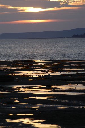
The Acadians farmed along the shores of the Bay of Fundy and Minas Basin, building dykes to hold back the high tides and planting grain on the reclaimed salt marshes. Although the Acadians remained politically neutral during the French-Anglo Wars, the British saw their presence as a threat and, in 1755, colonial officials expelled them from Nova Scotia. In 1995 the Grand-Pré area was declared Canada’s first Rural Historic District.

Ongoing archeological digs are locating building stone foundations and other artifacts of the Acadian inhabitants that were forcibly removed and their village burned by the British authorities. The Acadians were scattered amongst the other English colonies and some were sent back to France. Many families were split apart, never to see their loved ones again. They were not always welcomed in the other English colonies and that forced them to move from area to area until finally settling in places like Louisiana.

Many Acadians did find their way back to their beloved north and reestablished communities in areas that were once theirs exclusively. The British, after removing the Acadians, transported Englishmen into the areas to take over the rich lands and assist in controlling the seaways. Although many of the villages were burned, some towns were merely renamed and resettled by these new residents. Annapolis Royal is one such renamed town.
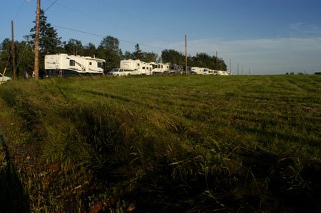
After our visit to Grand Pre’, we drove on to our campground in Annapolis Royal. We got things set up and then had a relaxing picnic dinner with out travel buddies, followed by delicious Nova Scotia ice cream.


Later in the evening many of us went on a fun graveyard tour in Annapolis Royal. The guide was dressed in Victorian mourning suit and gave a very informative historical tour of the graveyard. He traces his family back to the original Acadian settlers in this town and shared some of his family’s trials of getting back to this settlement. As we toured, the fog moved into the graveyard to lend an eerie feeling to it all.

Thursday, July 27, 2006

Rafting the tide

This is what we did on July 26th....

Today we experienced the high Bay of Fundy tides by taking a raft trip on the Shubenecadie River. As we wrote before, the Bay of Fundy is noted worldwide for its high tides and in addition its tidal bores.
The tide water enters the bay at its widest point, and as it passes along toward the head of the bay, it is in effect squeezed by the ever narrowing sides of the bay and by the constant shallowing of the bottom. At the very head of the bay, the advancing tide becomes a wave varying from just a ripple to 10 feet in height and this wave continues up the Shubenacadie River. This wave is known as a tidal bore. So, we have the phenomenon of the river changing its flow, with the bore wave flowing in OVER the outgoing river water.

OK-now you know what the tidal bore is --what we did is ride in Zodiac rafts chasing, surfing and jumping the tidal surge. What a wild ride! We got soaked to the skin. This is a photoof us with Mel and George, our travel buddies taken before the trip up the river.


This is a photo of our boat as it passed by an observation deck. Don't we look a little wet?
Fortunately, we had a sunny day and the water is about 75 degrees. We found the water temperature surprising but apparently it has to do with all the depth changes..

Another exciting part of the trip is when our boat lost its steering! One of the other rafts towed us part of the way back, until the owner arrived with another raft and we moved across to it while drifting down the river.

The whole phenomenon is amazing. We actually boated out to a sandbar that was about a mile across. We stood out there and the incoming tide rises so rapidly that one minute you are standing on sand and less than 2 minutes later the water is ankle deep! We returned to our boat as the bore washed over the sandbar. We continued up the river to play in the waves, currents and whirlpools. On our way back, the same sandbar was covered by 18 feet of water.

All in all, it was a fun day but very exhausting. Here are few photos from the raft company's web site that show the kind of ride we experienced.

Those waves came crashing over us and even filled the boat!


We rode wave after wave.


Doesn't this look like fun??


On to Nova Scotia

This si what we did on July 25th....

Last night, we attended a professional stage show of Anne of Green Gables. This theater production played to a sold out audience in the Charlottetown Confederation Theater. The show was very well done. We had a really good time. This is Canada’s longest running live show—about 15 years.

We woke early this morning to clear, blue skies! Finally, after several days of rain, it was a welcome change. Unfortunately we were leaving Prince Edward Island. It was a beautiful drive through the little towns and around the tiny harbors. Once again we crossed the nine mile long Confederation Bridge—our toll was $54.00!!

Our destination today was the village of Noel—on the Shubenacadie River where it flows into the Bay of Fundy. We are parked at Burncoat Point—a place where the Guinness Book of World Records states the world’s highest tide of 58.5 ft was recorded.

The village of Noel hosts motorhome caravans such as ours several times each summer. Since we are dry camping -we are the 3rd from the left-(no power, water, etc) the ladies in the town cooked us a delicious pot luck dinner this evening. Then one of the village officials told us about the town, the tides and some of their history. Everyone is so friendly.

After dinner we walked down to the river since it was low tide. Once again we were able to walk on the ocean floor. It is really amazing. Parked on the riverbanks, we watched the sun set over the water—such a lovely sight.


Tomorrow we are rafting the river during the bore tide. It’s supposed to be a wet and wild time.

Monday, July 24, 2006

Exploring the North End of PEI

Under gloomy skies we set off to drive to the area of PEI known as the North Cape. PEI is shaped like a smile ---we are parked in the middle and we drove out to the top left tip (Northwestern tip) of the smile.
Heading west ,we drove through town of Summerside--here the island is only 4 miles wide-- and out to an area of the Southern shore known as La Region'Evangaline. This is an area of PEI that was first settled by the French in the early 1700's. This group of close knit people (the Acadians)have preserved their language and unique culture. The Acadian flag is displayed prominently on properties, mailboxes and businesses. We made a short visit to Norte-Dame-du-Mont-Carmel church overlooking the water. It is a magnificent, turn of the century Neo-gothic structure.

We continued along through acres and acres of lush farms and spectacular sea scapes. Our next stop was the Jacque Cartier Provincial Park. Here we found a statue commemerating the spot where Cartier, the French explorer, first set foot on PEI in 1534. He declared this "the fairest land 'tis possible to see".

The friendly attendant at the park told us the "mossers" were working nearby and gave us directions on how to drive onto the beach to watch them. The "mossers" are workers that harvest Irish Moss seaweed from the ocean. This seaweed (after drying and processing) is widely used in the food industry as a thickener. Jams, jellies, ice creams and jello are just a few of the products that use the moss thickener known as carageenan
We hurried down to the beach to watch them. Here one of the horses is pulling a basket through the waves to strain the moss.


This is what the moss looks like before it loaded into the workers pick up trucks and taken to be dried.


In addition to the horses, some of the men hand rake the shallow areas for the moss. They sure were working hard!


Sometimes, the waves got a little close to the horses! What cold work for man and beast.


The result of all that work and raking are huge piles like these of the moss.

We are not sure we can ever eat jello (or any food that uses this kind of additive) again without remembering these hardworking fellows and their horses.
We did drive all the way to the North End of the island. There is a lighthouse there as well as a large sight with windmills. The University of New Brunswick is conducting experiments with wind energy (it is ALWAYS windy here) and the windmills currently supply 5% of PEI's energy needs


On the way south, we stopped in here. Yes, we did try the seaweed pie. It is quite tasty and nothing like what we expected. However it was light green!


After returning from our expedition, we joined the rest of our group and went to the Fisherman's Wharf Lobster supper. In addition to a yummy lobster, we had "all you can eat" locally harvested mussels and a great salad bar. What a great day .

Saturday, July 22, 2006

Prince Edward Island Tour

Today was our first full day on Prince Edward Island. After last night’s heavy rain, it was great to wake up to dry weather, even if it was rather overcast.. We were scheduled for a bus tour of the island.
We piled on the bus for a short drive to our first stop, Green Gables, Lucy Maud Montgomery’s Cavendish National Historic Site. This site served as much of the inspiration for L.M. Montgomery’s classic, Anne of Green Gables. In real life, this home belonged to David and Margaret MacNeil, cousins of Montgomery’s grandfather. The home is furnished much as described in Montgomery’s book. We saw two movies that told of L.M. Montgomery’s life.
There was also a barn which was typical of a Prince Edward Island farm in of the late 1800’s. Farm equipment and tools from the period were on exhibit. Two of the young workers were giving a demonstration on butter churning. It sure seemed like a lot of work. I'm afraid there would not have been much butter in our house!!

Next we drove on through part of Prince Edward Island National Park to some of the coastline that LM Montgomery (or Maud as she preferred to be called) loved to come to and often wrote about. Even on an overcast day like this, the sand dunes and red cliffs were beautiful.
We continued to drive along the coast. Our guide explained how the
Beach (and the island) is eroding along this North shore at the rate
of several feet each year. The province has to continually move
the road as the sea comes closer and closer.
Next we drove on down the road to North Rustico, a small lobstering
community. There, our guide gave us a talk about how the lobster pots work and how the fishermen get the lobsters in the boat. She also told of how costly it is for all the equipment the lobstermen must have. It’s a lot of hard work!!-no wonder those tasty critters can cost so much!

Next we were off to the PEI Preserve Company for a yummy lunch. We were warmly greeted by the owner who told us the story of how he came to own this property and run this company. It was a great place. The preserves we tasted were really delicious and most everyone who boarded the bus was carrying a bag of goodies from the gift ship. In addition, there was an ice cream stand with homemade ice cream that was some of the best ice cream we have had in a long time.
At the end of the tour, we drove through the countryside. The green, rolling hills were so pretty. Our guide told us that someone at one of the universities did a study and found 83 shades of green on PEI. This really seems true. Our last stop was at an overlook where we could see farmland, fishing village and aquaculture in the bay (mussel and oyster beds).
PEI is really a beautiful place. All of people have been very friendly and welcoming. We really enjoyed our tour.
Tomorrow we will explore the island again.

Friday, July 21, 2006

Crossing to Prince Edward Island

In the last 24 hours, we have been busy. After our walk on the ocean floor, we came back to the campground. We discovered earlier that there was a Costco in Moncton, just 27 miles away. We decided to take advantage of our membership and somewhat lower prices, so off we went. George and Merrily(two of our caravan buddies) drove and we managed to almost fill a cart with stuff. One thing we found interesting is that milk is sold in bags! Good thing we have a container! On the way back, we saw a McDonald’s—the sign in front said “McLobster is back!” FYI—it is good (of course we HAD to try it) and only available in Canada. We returned in time for ‘social hour” with some local entertainment.

This morning we left our campground in New Brunswick. Destination: Cavendish, Prince Edward Island. We drove through the town of Moncton and up to the Northern coast. There we entered onto Confederation Bridge to the island. This bridge, built in 1997, is 9 miles long! It is 145-200 feet above the water. It is a toll bridge, but toll is only paid when one drives back to the mainland. The toll for a car is $40.50 and our toll is more. Can you imagine being a resident and having to pay that every time one traveled to the mainland?

The road to our campground passed through lovely green hills and acres and acres of potato farms. Prince Edward Island supplies 80% of Canada’s potatoes. We passed Cavendish Farms, supplier of French fries for Burger King and Wendy’s in the US.

Shortly after we arrived, we had a social hour/birthday celebration for one of our traveling companions. Unfortunately it started to rain at the same time (tropical storm Beryl is passing over us). What we will do for a piece of cake!!

Tomorrow we will be taking a tour of the island. The rain is supposed to pass—we are keeping our fingers crossed.

Thursday, July 20, 2006

Enjoying New Brunswick


We have really enjoyed our time in New Brunswick. The pictures that follow are from our visit to Hopewell Cape in the Bay of Fundy. Tomorrow we are driving from here to Cavendish, Prince Edward Island. We cross an eight mile long bridge to reach the island. We are looking forward to seeing the Prince Edward Island (PEI).

This move is quite a bit north,so.... We may lose our ability to continue posting regularly on the internet. We are not sure of the Northern border of our satellite coverage. If you don't see any new posts assume that is the case and we will post again anytime we come across an internet signal. Canada is very forward thinking and seems to have a fair number of Wi-Fi spots. Wish us luck!!


Karen on the ocean floor- Bay of Fundy, New Brunswick. At high tide the water is 30+ feet higher than this! Pretty amazing.


Jim on the ocean floor, Bay of Fundy, New Brunswick.


View from above of the Flower pot formations at low tide. It's 99 steps from this point down to the ocean floor.


Flower pot formations at Hopewell Cape. Low tide--lots of people walk on the ocean floor some 40 feet below the top of these formations.


Kayakers at the high tide maneuver around the Flower Pot Formations


We visited the Bay of Fundy today. These rocks are known as the Flower Pots at Hopewell Capre, New Brunswick. This is high tide, about 30 feet.

Wednesday, July 19, 2006

New Brunswick Coast

Today we moved from the capital city of Fredericton to the coast of New Brunswick. We are now in the Bay of Fundy area, home of the world's highest tides. The area around Fredericton consisted of gently rolling hills and river valleys. We crossed into and through a landscape known as Maritime Acadian Highlands. The land rises abruptly from the sea and is covered with lush forests and deep valleys. This made for some interesting driving--very steep, winding roads that lead out of the forest and down to the fishing village of Alma.

Situated on the Bay of Fundy, this village has an small but interesting wharf area. We visited at low tide. I don't think these boats are going anywhere for the time being!
We want to go back at high tide and see if the boats are still there.


On our way back to our campground, we stopped by this little lighthouse known as Cape Enrage . It was a cute little lighthouse, but we thought the ones in Maine and Massachusetts were prettier.

Tomorrow we are going to explore some of this area. At low tide we will actually get to walk on the ocean floor. Should be very interesting, eh? (Don't we sound Canadian?)

Tuesday, July 18, 2006

Fredericton, New Brunswick

We spent today exploring Fredericton, New Brunswick by carpooling to the city parking lot and taking a guided walking tour of many of the historically significant buildings. These buildings were in the original area of the English settlement. The first Europeans to inhabit this area were the French. The British garrisoned troops here in 1784 after the American Revolution, when the King granted many of his Loyalist civilians land after their “removal” from the new United States.
They have managed to retain buildings that were built in the 1800’s and 1900’s. Some of the military buildings are still government owned and some are now housing businesses. Several of the original buildings (1784 era) are now used by the local government. Our tour guides were very well informed about all aspects of the town’s history.
The original occupant of the white house you see here has a direct connection to the war for U.S. independence. His name was O’Dell and he was the man who assisted Benedict Arnold in his efforts to sell out the U.S. West Point garrison to the British. Arnold was reputedly a guest in this house after escaping from the U.S. The guide said Arnold also actually owned some property just a ways from Fredericton on the river but he was never very well liked by the populace.
The fountain we are sitting upon is situated in Phoenix square. It’s called Phoenix square because the city hall behind the fountain was burned to the ground 3 times. Each successive building was more beautiful than it’s predecessor. The golden boy statute behind us is known as the “Little Nude Dude”. His placement on the fountain was cause for dismay by the town’s Victorian ladies, as he is “anatomically” correct! They requested his removal or that he be covered up, but the city fathers declined to do either. The original was later stolen, broken apart and discarded, but he was found, repaired and is now protected in a glass case. The one on the fountain is a duplicate
We got to watch a ceremonial changing of the guard in the city square. It was accompanied by bagpipers and included a review of the troops. You can see that some of them don't even shave! They do this 2 times day all summer. The city really goes out of their way to promote tourism. They even presented us with official visitor certificates and city pins..
We finished the day with a hail accompanied downpour and windstorm that actually ripped an awning off one RV in the park. Not ours!! But we know how the poor people feel since it happened to us in Apache Junction several years ago.

Monday, July 17, 2006

Kings Landing New Brunswick

Yesterday we packed up the motor home and drove north to Canada. After an uneventful border crossing (we had been told the Customs officials liked to search RV’s), we headed to a campground outside Fredericton, New Brunswick.

Our first stop was Kings Landing Historical Settlement. Situated on the banks of the St John River (at 418 miles, longest river in Eastern North America) Kings Landing is a living history re-creation of life in rural New Brunswick during the 19th century. All of the buildings are from that period of time and all of the equipment and tools used are 19th century.

This stove was in the kitchen of one of the homes. Note the oven chamber at the top. The families who “live” here cook and bake on the stove everyday. They also churn their own butter, can vegetables, and make cheese.

The gardens throughout the settlement looked quite healthy and productive. In addition to feeding the workers they supply the Kings Head Inn. This authentic 1855 restaurant and pub serve village visitors typical dishes from the period.


This is the sawmill on the river. The up and down saw is driven by water. We saw other machinery driven by water, horse and oxen power. They even had a butter churn that was moved by dog power! These oxen were being lead out to mow hay.

In addition to working the fields, the men also worked in the grist mills, the blacksmith shop and carpentry shops. The women were not idle at all. Of course, they cooked and cleaned. They also spun wool for yarn, knit garments, spun flax for thread and cloth and made clothing and bedding. They even wove their own straw hats! We watched many of the women performing these chores.

We had an enjoyable time learning how these Loyalists lived in the 19th century. Many aspects of their life were probably similar to the American pioneer—except for the British influenced society of course.